cheers guys i meant on the computer so i can upload stuff like this
| Hobie Forums http://www.hobie.com/forums/ |
|
| GPS suggestions? http://www.hobie.com/forums/viewtopic.php?f=69&t=13452 |
Page 3 of 4 |
| Author: | ChaosDave [ Thu Feb 11, 2010 6:25 am ] |
| Post subject: | Re: GPS suggestions? |
cheers guys i meant on the computer so i can upload stuff like this |
|
| Author: | chrisj [ Thu Feb 11, 2010 11:27 am ] |
| Post subject: | Re: GPS suggestions? |
Dave, you can save your tracks onto the computer in .gpx format. I don't think the Garmin software provides a specific plot of speed vs time/distance travelled, but you can use (free) third party software, such as GPS Action Replay to do in-depth track analysis. Another excellent piece of free software is GPSBabel, which enables you to export Google Earth (.KML) data to your Garmin. |
|
| Author: | KayakingBob [ Thu Feb 11, 2010 11:51 am ] |
| Post subject: | Re: GPS suggestions? |
I use GPSBabel to convert the Garmin .gdb to .gpx to post my tracks. Good program. |
|
| Author: | Cowsgomoo [ Thu Feb 11, 2010 12:11 pm ] |
| Post subject: | Re: GPS suggestions? |
Those graphics come from OziExplorer software. Very good software and allows you to import many types of maps (not supplied) But the new version now supports using Google Earth maps! http://www.oziexplorer.com/ |
|
| Author: | chrisj [ Thu Feb 11, 2010 1:26 pm ] |
| Post subject: | Re: GPS suggestions? |
reconlon wrote: I use GPSBabel to convert the Garmin .gdb to .gpx to post my tracks. Good program. Bob, my Garmin saves the tracks to the Micro SD card in .gpx format by default. Also, if you import your Active Log directly into Mapsource, you have the option to save it in .gpx format, without needing to invoke GPSBabel. |
|
| Author: | KayakingBob [ Thu Feb 11, 2010 2:17 pm ] |
| Post subject: | Re: GPS suggestions? |
Thanks! I'll have to try that. It will save time, as I'm trying to post each trip out now at: http://www.trailguru.com/ui/user/tracks/KayakingBob I also used http://www.gpsvisualizer.com/ to create a map of my January sails below. 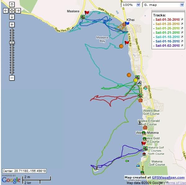
|
|
| Author: | chrisj [ Fri Feb 12, 2010 2:26 pm ] |
| Post subject: | Re: GPS suggestions? |
reconlon wrote: I also used http://www.gpsvisualizer.com/ to create a map of my January sails below. Spot on, Bob. Dave, you can also use gpsvisualizer, as mentioned by Bob, to create the track profile you were after, using a .gpx or a .gdb file: 
|
|
| Author: | ChaosDave [ Sat Feb 13, 2010 1:23 am ] |
| Post subject: | Re: GPS suggestions? |
cheers guys that GPS visualiser looks good. Another question to the guys with the GPSmap 60's how did you mount yours? I want to get a ball RAM mount i think but think the hobie ones are specifically for the lowrance finders and not sure if they will fit the garmin. Garmin do do a flimsy mount, but you can't put the gps in a protective bag as it attaches to the clips. |
|
| Author: | KayakingBob [ Sat Feb 13, 2010 9:52 am ] |
| Post subject: | Re: GPS suggestions? |
Mine is ball mounted in a holder made for the GPSmap 76's sold by RAM. My first GPSmap 76 started dying the 2nd trip out. I talked to Garmin and they agreed to replace it. I have since filled all the ports with dielectric grease to keep any salt water out of the "ports" with great success. I also glued a piece of hard plastic to the back of the holder behind the GPS, to keep wind and waves from trying to opening the ports.  If you look close, both the GPS, the holder and mount are all leashed to the hull (I don't trust anything not leashed down, to still be with me after going through our wind and waves!) |
|
| Author: | ChaosDave [ Wed Feb 17, 2010 3:45 am ] |
| Post subject: | Re: GPS suggestions? |
thanks bob anybody else have any recomendations i have seen the RAM's aquabox that looks good but is bloody expensive, like $100 with ball. |
|
| Author: | ChaosDave [ Thu Feb 18, 2010 4:53 am ] |
| Post subject: | Re: GPS suggestions? |
another question, my GPS can apparently give depth alarms but needs some kind of adaptor has anybody managed to connect there GPSmap up to transducer? |
|
| Author: | Cowsgomoo [ Thu Feb 18, 2010 9:35 pm ] |
| Post subject: | Re: GPS suggestions? |
ChaosDave wrote: another question, my GPS can apparently give depth alarms but needs some kind of adaptor has anybody managed to connect there GPSmap up to transducer? I'd imagine you need a depth finder putting out NMEA protocol with depth info on the interface. |
|
| Author: | ChaosDave [ Fri Feb 19, 2010 3:14 am ] |
| Post subject: | Re: GPS suggestions? |
Cowsgomoo wrote: ChaosDave wrote: another question, my GPS can apparently give depth alarms but needs some kind of adaptor has anybody managed to connect there GPSmap up to transducer? I'd imagine you need a depth finder putting out NMEA protocol with depth info on the interface. spot on the manual says depth requires nmea input, but says little about what that actually is, guess its google time. |
|
| Author: | Cowsgomoo [ Sat Feb 20, 2010 3:01 am ] |
| Post subject: | Re: GPS suggestions? |
ChaosDave wrote: Cowsgomoo wrote: ChaosDave wrote: another question, my GPS can apparently give depth alarms but needs some kind of adaptor has anybody managed to connect there GPSmap up to transducer? I'd imagine you need a depth finder putting out NMEA protocol with depth info on the interface. spot on the manual says depth requires nmea input, but says little about what that actually is, guess its google time. NMEA is a standard way of marine electronic devices to talk to one another over a serial interface. The information looks something like this- Quote: $IIAPB,A,A,0.68,L,N,,,236.5,T,WP07,236.5,T,236.5,T*39 $IIBWC,140000.00,5410.000,N,01300.057,E,236.5,T,236.5,M,5.7,N,WP07*3D $IIDBT,66.0,f,20.0,M,8.7,F*1C $IIGGA,140010.00,0127.013,S,04831.001,W,1,07,1,0,M,,,,*2C $IIGLL,0127.013,S,04831.001,W,140010.00,A*11 $IIGSA,,3,20,11,07,01,25,14,04,,,,,,,1,*79 $IIGSV,2,1,24,20,75,255,43,11,55,150,46,07,37,288,39,01,28,193,48*6F Format of the depth sentence looks like this- Quote: $--DBT,x1,f,x2.x3,M,x4,F*hh<CR><LF> 1) X1 = Depth, feet 2) f = feet 3) x2 = Depth, meters 4) M = meters 5) X4 = Depth, Fathoms 6) F = Fathoms 7) hh = Checksum All way too much information really but it shows how these devices talk. You "should" be able to just hook things up and configure them to work. Of course having interface cables running about can get messy and asking for salt water ingress. I'd have thought a depth sounder is going to have a depth alarm anyway so there'd be no need to send depth info to the GPS unless you want to log it. |
|
| Author: | ChaosDave [ Mon Feb 22, 2010 3:39 am ] |
| Post subject: | Re: GPS suggestions? |
I just got a reply from garmin apparently you can plug one of these intelliducer's straight into your gpsmap and it will give you depth warnings. https://buy.garmin.com/shop/shop.do?cID=288&pID=26514#productTab however for the price you might aswell buy a half decent fishfinder, its just that the less wires the better and the AI is lacking the mounting area that some of the other Hobies have. |
|
| Page 3 of 4 | All times are UTC - 8 hours [ DST ] |
| Powered by phpBB® Forum Software © phpBB Group http://www.phpbb.com/ |
|