Brady,
Here is a picture of National Geo TOPO! map for an area you are familiar: Matheson Hammock Park.
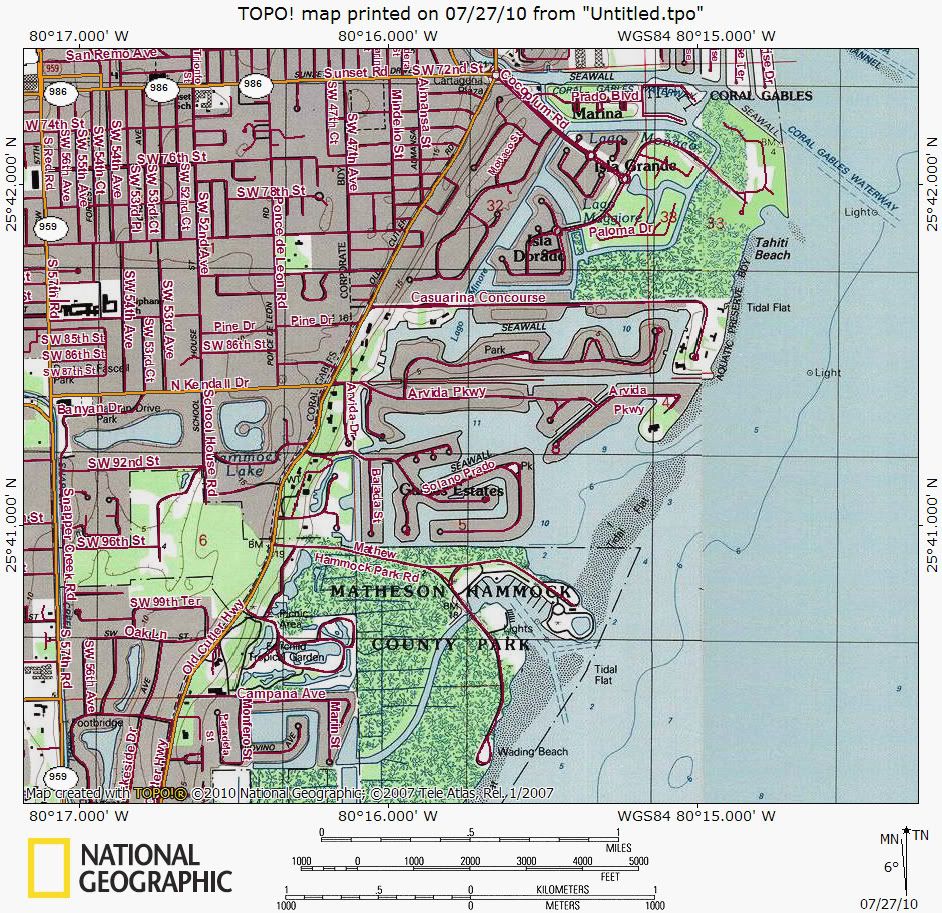
Now, I am sure that Garmin Topo map software--which allows you to upload maps to your GPS--probably does not give this much detail. National Geographic digital maps are some of the best available. Garmin's Topo maps for their handheld gps units give fair maps on your gps--not great maps. I'm out in New Mexico at 9500' so it is not convenient for me to look at my Garmin gpsMAP 76CSx to see what the Matheson area looks like using Garmin TOPO Florida maps.
Still, the Garmin Topo maps have always been adequate for the shoreline of FL for the style of kayaking and AI sailing that I do. These maps do show some buoys. I don't remember that they show much in the way of channels or depths. Most of the time, when I am doing a trip, I have a route laid out (prepared using NG TOPO!) which will route me around shallow areas and into a channel if necessary. But, as an AI sailor in the shallow waters of FL, you will be constantly on the lookout for areas of shoaling independent of what your charts or gps says. On our recent kayak trip along the Florida Big Bend area (which I plan to do in my AI next year) there are many oyster bars and gravel bars which are never going to show up on any marine charts other than in a very general way. You have to be on alert all the time unless you are well off shore. And, as you know, if you do happen to sail into a shallow area, it is a fairly minor problem for an AI/TI. Sailing onto an oyster bar is a bit more serious—keep your eyes open.
With sailing time, you will become very familiar with the waters you regularly sail in, such as Biscayne Bay or the waters out of Flamingo. Charts will be truly unnecessary most of the time. If you have NG TOPO!, you can lay out a route to get you to various points even for a day sail when you are in unfamiliar waters. Also, before you ever get on the water you can put wpts on your gps to guide you. For example, if you were to sail out of Matheson marina, put a wpt for Matheson on your gps using TOPO! or, simpler, when you are launching your boat, put a wpt in for your launch site. Go out and sail around for a couple hours, then pick that launch wpt off your gps wpt list, and do a GOTO. Follow the GOTO to get right back to Matheson.
Again, take your gps for a walk around the neighborhood. Put in wpts at corners, then, when you get home, use those wpts to make a route on your gps (you could also lay out a route in your neighborhood w/ NG TOPO!) Once you have your neighborhood route on your gps, next time you go out, tell your gps to follow that route. Then see how the gps, the display, behaves as you follow that route. See how it behaves as your cut corners and deviate from the route. You can learn a lot about your gps just using it on neighborhood walks.
Be sure to learn the difference between a GOTO and a route. Both can get you to a destination but in very different ways.
Keith